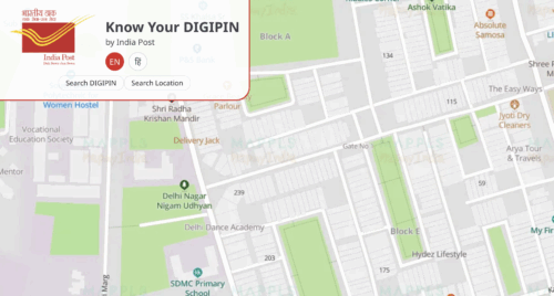
What Is DIGIPIN?
More than five decades after the six-digit PIN code changed mail delivery in India, the Department of Posts has launched DIGIPIN. It is a 10-character alphanumeric code that maps exact GPS coordinates for every 4×4 metre grid in the country. This means every home, shop, and landmark can now have a unique digital address.
Who Developed DIGIPIN?
DIGIPIN is a joint effort by India Post, IIT Hyderabad, the National Remote Sensing Centre, and ISRO. The system uses satellite mapping and geospatial technology to convert latitude and longitude into a machine-readable code.
How Does It Work?
Each code is tied to a specific 4×4 metre area. Unlike traditional PIN codes, which cover an average of 170 sq. km, DIGIPIN offers pinpoint accuracy up to 4 metres. This makes it useful for hyper-local deliveries, especially in remote or unmarked locations.
How to Find Your DIGIPIN?
Finding it is simple:
- Visit the “Know Your DIGIPIN” portal at dac.indiapost.gov.in
- Allow location access or manually enter your address
- Click “Generate DIGIPIN” to view your code
The tool works only if your device has location sharing enabled.
Benefits of DIGIPIN
It offers multiple advantages beyond faster mail delivery:
- Enables last-mile e-commerce and food deliveries
- Assists emergency services with precise locations
- Helps in disaster relief and recovery
- Supports government welfare distribution
- Simplifies address verification for banking and KYC
By mapping unnamed streets and remote locations, DIGIPIN reduces delivery errors and ensures quick access to services.
Challenges in Urban Use
While DIGIPIN is accurate on the ground, multi-storey buildings present a challenge. The system is grid-based, so different floors in the same building share the same code. Future updates may address vertical mapping for better urban coverage.
Future Plans for Digital Addressing
India Post plans to introduce a digital address layer, similar to UPI IDs. Users could create unique, easy-to-remember tags like username@domain linked to their DIGIPIN and full address. This would make sharing location details as simple as sharing an email ID.
Cross-Border Mapping
Interestingly, the 4×4 metre grid also covers parts of neighbouring countries like Pakistan, Myanmar, and Bangladesh. This means the system can technically generate DIGIPINs for those areas too, though they are not active for Indian postal operations.
Why It Matters?
DIGIPIN is part of India Post’s IT 2.0 modernisation programme. With integration into mobile devices used by postal staff, it will support online postal, financial, and insurance services. It also lays the groundwork for future drone-based deliveries and AI-driven logistics.
